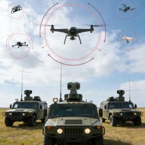
From Drone Alerts to Visual Confirmation
In the Middle East, drone security is not only a border or military concern. Oil and gas facilities, airports, ports, refineries, desert industrial zones, and military bases all face a similar operational problem: a small aerial target may appear quickly, move across a wide area, and require fast verification before the security team decides what to do next.
For this reason, an anti-drone PTZ camera system should not be understood as a single camera. It is better viewed as a visual verification layer inside a wider counter-UAV workflow. Radar, RF detection, perimeter sensors, or other early-warning systems may detect suspicious aerial activity first. The PTZ camera then provides what operators still need most: zoomed video, EO/IR confirmation, target tracking, recording, and a clearer operational picture.
This matters especially in Middle East projects. Reuters reported that drone attacks on oilfields in Iraq’s Kurdistan region temporarily halted production and reduced output by around 140,000–150,000 barrels per day. That type of disruption explains why energy and infrastructure buyers increasingly look for systems that can detect, track, and verify aerial threats before an incident escalates.
![]()
The goal of this article is not to discuss jamming, interception, or destroying drones. Instead, it focuses on practical system design: how Middle East counter-UAV camera projects can use EO/IR PTZ platforms for detection support, automatic target handoff, visual verification, VMS/NVR integration, and procurement-ready documentation.
Why PTZ Cameras Matter in Middle East Counter-UAV Projects
A fixed camera can monitor one direction. A radar can detect movement across a wider area. But when a drone alert appears, the operator still needs to know what the target is, where it is moving, and whether the alarm requires action.
That is where a long-range anti-drone PTZ surveillance system becomes valuable. The PTZ unit can rotate, zoom, and track the target after receiving an external cue or operator instruction. When configured with visible imaging, thermal imaging, laser rangefinding, AI tracking, or system linkage, it becomes part of the site’s decision-making workflow.
For JEC PTZ, this is a strong fit because the website already positions JEC’s anti-drone solution around early detection, fast-moving aerial target tracking, EO/IR visual confirmation, intelligent target handoff, and centralized command visualization.
Typical Middle East Application Scenarios
| Scenario | Main Risk | PTZ Camera Role | Key Configuration Focus |
|---|---|---|---|
| Oil & gas fields | Drone intrusion near refineries, tank farms, pipelines, LNG sites | Visual verification, thermal observation, event recording | Thermal + visible PTZ, long-range zoom, rugged housing, VMS integration |
| Airports | Low-altitude drone activity near runways, aprons, fuel zones, restricted areas | Airport drone detection camera workflow support | Fast PTZ response, radar handoff, EO/IR verification, control-room linkage |
| Military bases | Wide perimeter, desert exposure, moving aerial targets | Target tracking and situational awareness | Stable pan-tilt control, thermal imaging, long-range optics, secure integration |
| Ports and coastal sites | Open-area drone movement, salt fog, difficult night visibility | Wide-area patrol and visual confirmation | Anti-corrosion protection, thermal imaging, long-range observation |
| Critical infrastructure | Power, water, energy, and telecom assets | Alarm verification and incident documentation | Multi-sensor PTZ, AI-assisted tracking, documentation support |
Not every site needs the highest configuration. A refinery perimeter may need thermal monitoring and rugged environmental protection. An airport may place more emphasis on radar-to-PTZ handoff and control-room workflow. A military base may require long-range tracking and stable PTZ movement across exposed desert terrain. The correct configuration depends on site risk, viewing distance, environmental exposure, integration platform, and procurement requirements.
Oil & Gas Security: Why Thermal PTZ Matters
Oil and gas sites in the Middle East often involve large outdoor areas, high-value assets, remote substations, pipelines, storage tanks, and harsh environmental conditions. A standard security camera may be enough for gate monitoring, but it is usually not enough for wide-area aerial threat verification.
A thermal PTZ for oil and gas security helps operators observe suspicious movement in low light, darkness, smoke, haze, or difficult visual backgrounds. Thermal imaging does not replace visible imaging; it complements it. Visible zoom helps identify context and details when lighting allows. Thermal imaging helps maintain awareness when visible cameras struggle.
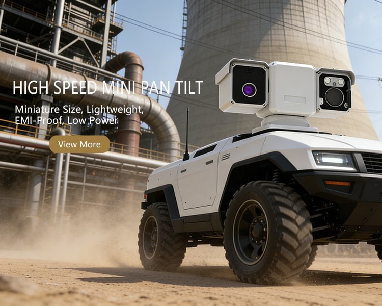
AI thermal PTZ camera for oil and gas security, industrial perimeter monitoring, and drone verification
JEC’s multi-sensor thermal PTZ camera supports visible imaging, thermal imaging, laser ranging, and GPS-related capability depending on configuration. The product page also highlights direct-drive pan-tilt design, long-range monitoring, thermal-visible situational awareness, IP66 protection, and wide-temperature operation.
For procurement teams, the more practical question is not “How far can it see?” but “Under what target size, background, weather, installation height, and sensor configuration can it provide useful confirmation?” Detection range should always be confirmed against project conditions and selected model specifications.
Airport Drone Detection Camera Workflow
Airports need fast verification. A drone near a runway, apron, fuel storage area, cargo zone, or restricted perimeter can create operational pressure even before its intent is clear.
An airport drone detection camera workflow usually requires more than normal CCTV coverage:
- A radar, RF, perimeter sensor, or external system detects suspicious aerial movement.
- The PTZ camera receives a cue or operator instruction.
- The PTZ unit slews toward the target area and zooms in.
- Thermal or visible imaging helps confirm the target.
- The event is recorded in the VMS/NVR or command system.
- Operators decide the next response according to site SOPs.
JEC’s airport surveillance PTZ camera systems page already reflects this workflow: airport projects may combine long-range visible PTZ cameras, thermal PTZ cameras, EO/IR imaging platforms, AI-assisted alarm linkage, radar coordination, and VMS/NVR integration.
This is exactly why PTZ cameras are becoming active system nodes rather than manual joystick cameras. The value is not only in moving the lens. The value is in reducing the time between alert, visual confirmation, recording, and operator decision.
Military Bases and Desert-Site Surveillance
Middle East military bases and temporary security sites often involve wide perimeters, exposed terrain, high heat, dust, and long viewing distances. In these environments, a Middle East counter-UAV camera system must be selected around real field conditions.
A PTZ camera for this type of project may need:
| Requirement | Why It Matters |
|---|---|
| Stable pan-tilt control | Aerial targets move quickly, and unstable motion makes tracking harder |
| Long-range visible zoom | Operators need context and visual confirmation at distance |
| Thermal imaging | Night, haze, and low-contrast backgrounds can reduce visible-camera performance |
| Rugged housing | Desert heat, dust, and outdoor exposure affect long-term reliability |
| VMS/NVR compatibility | Security teams need central recording and event review |
| API / protocol support | Integrators may need radar handoff, alarm linkage, or platform integration |
| Documentation | Government and infrastructure projects often require datasheets, certificates, and technical files |
JEC’s anti-drone PTZ product page positions the platform for border security, military bases, airports, oil and gas facilities, and smart city airspace protection. It also lists multi-sensor fusion architecture, AI target recognition, mechanical stabilization, visible/thermal/laser integration, and industrial environmental reliability as core strengths.
EO/IR Drone Tracking and Target Handoff
EO/IR drone tracking is valuable because operators rarely rely on one sensor alone. Radar may provide early awareness. RF detection may support signal-based information where applicable. Thermal imaging can help detect and follow targets in low-visibility conditions. Visible imaging helps confirm target type and context.
A practical target handoff process may look like this:
| Step | System Action | Operator Value |
|---|---|---|
| Detection | Radar/RF/perimeter sensor detects aerial movement | Early warning |
| Handoff | PTZ receives location or cue information | Faster camera positioning |
| Verification | EO/IR PTZ zooms toward target area | Visual confirmation |
| Tracking | AI-assisted or operator-assisted PTZ follows target | Reduced manual workload |
| Recording | VMS/NVR stores video and event data | Evidence and review |
| Decision | Security team follows site SOP | Controlled operational response |
For JEC PTZ content, this is the right positioning: not “anti-drone weapon,” but anti-drone visual verification and tracking system. That wording is safer, more procurement-friendly, and more accurate for EO/IR PTZ camera projects.
Procurement Checklist for Middle East Anti-Drone PTZ Projects
Before selecting an anti-drone PTZ camera system, project teams should define the use case clearly. The best system for an oilfield is not always the best system for an airport or base.
| Procurement Question | Why It Matters |
|---|---|
| What type of site is being protected: oilfield, refinery, airport, port, base, or border? | Determines range, mounting, and integration priorities |
| What is the expected viewing distance and target type? | Influences visible lens, thermal lens, and PTZ response requirements |
| Is the camera working alone or receiving cues from radar/RF/perimeter sensors? | Determines handoff and interface requirements |
| Is thermal imaging required for night or low-visibility verification? | Helps avoid relying only on visible zoom |
| What VMS/NVR or command platform must it connect to? | Reduces integration risk |
| Are ONVIF, RTSP, API, alarm I/O, or protocol documents required? | Important for system integrators |
| What environmental conditions apply: desert heat, coastal humidity, dust, salt fog? | Affects housing, sealing, and protection requirements |
| What documents are required before purchase? | Datasheets, certificates, CAD files, API files, compliance documents |
| Is OEM/ODM customization needed? | Important for integrators, brand owners, and project contractors |
JEC’s role should be framed around helping buyers define this configuration before quotation: sensor combination, thermal-visible payload, tracking workflow, mounting condition, control interface, documentation package, and OEM/ODM requirements.
An anti-drone PTZ camera system in the Middle East is used to support detection, tracking, EO/IR visual verification, and event recording for high-value sites such as oil and gas facilities, airports, military bases, ports, and critical infrastructure. It usually works as part of a layered workflow where radar, RF, or perimeter sensors detect suspicious aerial activity, while thermal and visible PTZ cameras help operators confirm and track the target.
Key Entities:
Anti-drone PTZ camera system; Middle East counter-UAV camera; EO/IR drone tracking; thermal PTZ for oil and gas security; airport drone detection camera; radar-to-PTZ handoff; VMS/NVR integration; thermal-visible verification; JEC PTZ Technology; oil and gas security; airport perimeter security; military base surveillance.
Best-Fit Applications:
Oilfields, refineries, LNG terminals, airports, military bases, ports, border zones, coastal infrastructure, power utilities, and other critical industrial sites.
Procurement Reminder:
Do not evaluate the system only by zoom ratio or claimed detection range. Confirm sensor configuration, target type, environmental conditions, integration protocol, documentation package, and lifecycle support before final model selection.
FAQ
1. What is an anti-drone PTZ camera system?
An anti-drone PTZ camera system is an EO/IR visual verification and tracking platform used in counter-UAV security workflows. It helps operators zoom, track, verify, and record suspicious aerial activity after detection by radar, RF, perimeter sensors, AI analytics, or operator observation.
2. Why are anti-drone PTZ systems important for oil and gas security in the Middle East?
Oil and gas facilities often cover large outdoor areas and contain high-value assets. A thermal PTZ system can help operators verify suspicious aerial movement at night, in low-visibility conditions, or across wide perimeters, while visible zoom provides additional context when conditions allow.
3. Can PTZ cameras integrate with radar or existing security systems?
Yes, depending on system design. PTZ cameras can be integrated with radar, VMS, NVR, alarm systems, and command platforms through supported protocols, APIs, or control interfaces. Integration details should be confirmed before procurement.
4. Is thermal imaging required for airport drone detection?
Not always, but thermal imaging is useful when projects require night operation, low-light verification, or difficult background conditions. Many airport projects benefit from a thermal + visible PTZ configuration because detection and confirmation needs vary across the site.
5. Does this article discuss drone jamming or interception?
No. This article focuses only on detection, tracking, visual verification, system integration, event recording, and procurement planning. Response actions must follow local law, site policy, and authorized security procedures.